
COMPASS COURSE
By: Warrior Woman
There are a lot of different ways to run a compass course. Since I'd already had a bit of compass/topo experience, I got to start out the fun way - at night and in relatively unfamiliar territory. That hill in back of our house looked a lot different in the daytime, and there was a great deal of it I'd never covered. Now that I know where all the briars and burdocks are, it should be easier the next time....
At the end of this article are some links to sites that deal with compass course basics. I skimmed the sites for useable beginner information and found plenty!
Plotting the course
To plot the compass course, you need to have a topographical map of the target area and a drafting compass.
Get a good drafting compass - one that's numbered in both directions - before you start plotting courses. Drafting compasses are not numbered in the same plane as your navigational compass, so you need to make some adjustments to get the correct bearing. The sketch below illustrates this:
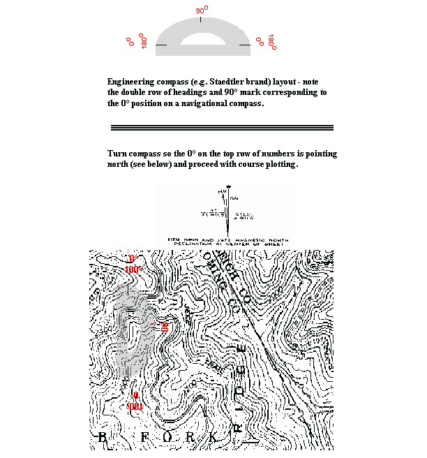
As you head in one direction keep in mind that you need to add/subtract 180 degrees to return to your original location. Think in terms of a circle divided into 360 degrees, with magnetic north being equal to zero, due east being 90, south being 180 and west being 270 degrees. The term "shooting an azimuth" can be simplified to "getting your bearing/heading" - in terms of the number of degrees your target lies at in relationship to magnetic north, or zero. A "back azimuth" is simply the original heading ± 180 degrees.
Since the maximum value is 360 degrees, an original heading of 270 degrees would require subtracting 180 to get the back azimuth, since adding would give you a sum of 450 degrees. Another way to do this is to always add, and then subtract 360 from the result if the sum is greater than 360; i.e. 270+180=450-360=90 degrees (due east). This is the same result as 270-180=90 degrees (due east). Pick the method that's easier for you! Declination is another subject, since magnetic north and true north are not the same. Topographical maps have a legend which gives the declination for that area. This subject can be better covered by reading some instructions on land navigation with map/compass.
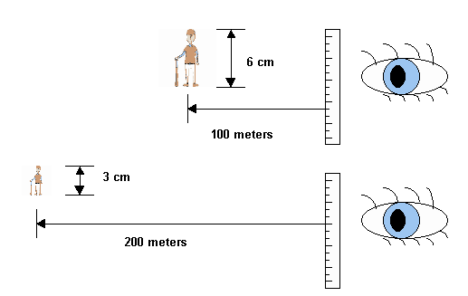
Distances were estimated but ranging the distance is the best method.
Ranging the distance can be done by using an object of known height - a person will do very nicely - at a measured distance. Hold a ruler up beside your face and measure the person at that distance. A simple ratio can then be used to determine any distance by the height of the person on the ruler.
Those of you with range-finding scopes will understand this one without explanation; however, for those who don't have experience in range-finding, the following should help clarify the technique:
Hm = Measured Height of Known Object
Dk = Known Distance to Known Object
Du = Unknown Distance to Known Object
m = meter
cm = centimer
x = times (multiply)
The simple algebraic formula for calculating ranged distances is:
Hm x Dk = Hm x Du
For the following sketch, the equation and solution are as follows:
0.06m (6cm) x 100m = 0.03m (3cm) x Du(m)
6 = 0.03 Du(m)
0.06/0.03 = Du(m)
Du(m) = 200m
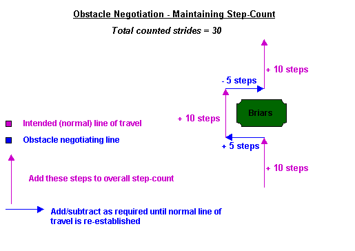
The course my partner laid out was a 2-leg up, 2-leg back that had us meeting up at the end of each of the second legs. While the first meet was perfect, the second one found me about 7 meters off course after my run-in with the briars: I had failed to properly re-negotiate the obstacle.
Preliminary Gear Check
It was a cool night, so we dressed for the occasion: fatigues, gloves, hats, field jackets, waterproof boots. Rather than going with full gear, we opted for standard web gear including compass, anglehead flashlight, 40-channel hi/lo CB, knife, canteen, etc. A list of "standard" items for web gear, along with recommendations for locating them on your WG, will be forthcoming in another section of this page.
When we were assembled, we did a gear check - this included both ease of access to the items on the web gear and a noise check. You can check your noise level by bouncing your gear - the bottom of my flashlight was making a terrible racket against a buckle. Most noise problems can be resolved by slipping a piece of rubber over the offending area; sections of bicycle tube work very well. Once the band was in place, my flashlight was silenced. All pocket and case closures were checked to make sure they were fastened.
Communications Check
After we were comfortably settled in our gear, we headed outside and did a radio check. We had agreed on an initial broadcast channel - we turned on the CB's, checked to make sure the channel was clear and free from chatter, adjusted the squelch, and turned the volume to the lowest level that was still distinguishable with the CB in its carrying case. Radio contact was to be made at the end of the first of each 2-leg segment or in case of a problem along the way. An alternate channel had been prearranged, as well as the sequence of drop-channels we would use in case we needed to avoid detection.
Each of us had a slip of paper with the target coordinates. While the paper was easy enough to read in the house and even outside under the security lights, it soon became obvious that the red lenses we'd chosen for our flashlights were going to be a problem; one of us was using a compass with red lettering which became invisible under the red light! Be sure to leave your flashlight at the first "on" setting so you can do a flash contact without fumbling. We switched to blue lenses, "charged" the compasses, and then set them for the initial leg of the course. We selected landmarks and headed out...
We were also using two different types of compasses, a Silva and a Lensatic. While the Silva system is wonderful in daylight hiking conditions, it leaves a lot to be desired for serious night work. The lettering is a bit small, there is no backlighting, and charging it as you walk transmits a beam of light that's visible for a long way. The Lensatic, on the other hand, fits over the flashlight head and blocks off nearly all the light - a big plus in avoiding detection!
Measuring Your Stride
This can be an exercise in frustration when you're working in mixed terrain, as we found out when we decided to double-check our stride lengths. While on the flatlands my stride is a consistent 0.833 meters, this changes to 0.81 going uphill in fairly uneven terrain and 0.78 going downhill over the same uneven terrain. In spite of what the books say, we found this to be true for both of us and chalked it up to the "braking" effect. My suggestion is to measure over a distance of at least 300-500 meters in a variety of conditions. Your stride at age 45 will not be the same as your stride was at 35; if you smoke, your stride over a distance will shorten considerably as uphill hiking takes a toll on your ability to breathe. A reel of kite string marked off in 100 meter increments can come in very handy for getting stride length down to a science in any terrain. As with everything, practice, practice, practice! While coming up short a meter every 200-300 yards may not seem important during practice, it can make a critical difference in an emergency situation when meeting up with your group members (and avoiding unfriendlies) is absolutely essential.
Night vs Daylight Navigating
Navigating at night was an experience for me - I've travelled in the woods at night while trail hiking, but had never run a compass course in the dark. Even with my glasses on, it was difficult to spot some of the low spots in the field, and I stepped off into "nothing" more than once. Since this can be a jarring experience, I would suggest taking smaller strides and accounting for this when you calculate the number of steps it will take you to reach the target coordinates.
My normal stride on level ground is 0.83 meters, which means I have to take 120 steps to travel 100 meters. In rough terrain, my stride is reduced to about 0.78 meters, and I have to add in the additional steps to account for that.
Trying to reset a compass in the dark is tricky until you get the hang of it. You need to hold the compass level, light up the dial while not broadcasting your position to the world, and find a new landmark after dilating your pupils with the shielded light. Since my arms are on the short side and my hands on the small end of the scale, I had to remove my flashlight from the clip on my web gear every stop, and then reattach it when I had finished resetting my compass. All of these movements became smoother after doing them a few dozen times - so again: practice!
Navigating Obstacles
After my experience with the briars and burdocks, I got a quick refresher on how to navigate my way around obstacles and calculate where I was in my step count. Basically, negotiate around the obstacle at 90 degree angles (same number of steps in each direction), and only count steps taken in the direction of your coordinates as part of your total step count. The steps taken perpendicular to your intended line of travel are added in one direction and subtracted in the other until you return to your normal heading.
Enjoy the nice weather - get out and "do" what we've talked about all winter, and let me know what you find out there!
~WWD
A Few Links For Starters
Finding Your Way with Map and Compass from the USGS presents the basics of using a compass and topo map for land navigation.
How to Use a Compass A tutorial that covers the basics plus, along with some good links to other info-sites on orienteering
USGS Topographical Maps - Locate sources by state for purchasing USGS topos
Survival Gear Sources for getting compasses, map cases, and other necessary items for your gear inventory.
BACK